When considering flooding we often think of rising rivers and coastal inundation, however there are many different forms of flooding - some of which you may be vulnerable to, irrespective of your proximity to a body of water.
Fluvial river flooding
This is the most well known type of flooding, and is where the volume of water in a river exceeds its capacity, causing it to overflow onto low-lying adjacent land. This adjacent land is often referred to as a flood plain, and by definition is the most likely area to flood.
Thankfully, river levels are closely monitored therefore this type of flooding can often be forecasted - although sudden and intense rainfall can often cause flash flooding, severely limiting the length of any prior warning, which is why you should always respond quickly to any flood warnings issued.
Groundwater flooding
Spelthorne is at risk of flooding from more than the visible and well understood River Thames (fluvial) floodwater. Flooding may be intensified by the time of year, duration and volume of rainfall. Groundwater is likely to be part of a flood combining visible river flooding with the sub surface saturated by rainfall and unable to absorb any more water.
There is the potential for groundwater to occur across most of Spelthorne due to the geological makeup of the local area. The underlying bedrock geology in Spelthorne is known as London Clay. On top of the clay there is a layer of river gravel deposits. Investigations indicate that the thickness of the gravel is commonly 5-7 metres. The cause of groundwater is that water is unable to drain into the impermeable London Clay. This results in the 5-7 metres of gravel lying on top of the clay to be left to hold the groundwater until saturation point which occurs when there is excessive rain. In this situation the water will appear on the land surface at the lowest points.
Surface Water Flooding
Surface water flooding occurs when rainwater does not drain away through the normal drainage systems or soak into the ground, but lies on or flows over the ground instead.
The urban landscape of Spelthorne means surface water flooding is a risk within the borough. Surface water flooding tends to fall particularly on urban areas, because they have more concrete. Urban areas with high density housing are the most susceptible of all, because there are many paved drives and parking spaces which don't absorb the rainwater, not big suburban lawns which do.
Surface water flooding can also be linked to groundwater flooding as explained in the above section.
Impacts on Spelthorne
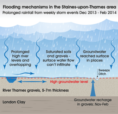
There is a complicated interaction between rainfall, surface water, groundwater and river levels (see diagram below). Typically, in winter months the gravels and top soils become increasingly saturated with water. There is also a link between the groundwater to the River Thames. When the river levels are high, due to the gravel bedrock, groundwater is likely to be at a similar level as the visible level of the river. With prolonged rainfall leading to increased groundwater, flooding may well also start to enter sub-surface drainage and foul sewer networks.
In addition to this, the surface water (water produced by rainfall directly on the ground) in Spelthorne predominantly discharges through the ground and into the 5-7-meter gravel layer. When the groundwater is high and the gravel saturated then the surface water is unable to drain into the ground. This water also results in visible surface flooding again, often seen at low points, roads being an example. Surface groundwater can affect the foul sewer networks in the same way as groundwater. Both surface water and groundwater can overload the sewers which can result in a mixture of ground, surface water and foul sewage water visibly flooding from drains to local areas and properties. Pumping the floodwater out will have very little benefit as the high groundwater will continue to replace any water which is pumped out. Only when the groundwater levels drop will the floodwater recede.
In summary, Spelthorne is at risk of groundwater flooding, where prolonged rainfall, commonly in the winter months, results in the saturation of the local gravels. Sustained high river levels and increasing groundwater levels following prolonged rainfall can result in surface ground water flooding.
